Radio Hill Mine, Karratha, City of Karratha, Western Australia, Australiai
| Regional Level Types | |
|---|---|
| Radio Hill Mine | Mine (Active) |
| Karratha | - not defined - |
| City of Karratha | Shire |
| Western Australia | State |
| Australia | Country |
This page is currently not sponsored. Click here to sponsor this page.

Latitude & Longitude (WGS84):
20° 59' 5'' South , 116° 51' 43'' East
Latitude & Longitude (decimal):
Type:
Mine (Active) - last checked 2025
Köppen climate type:
Nearest Settlements:
| Place | Population | Distance |
|---|---|---|
| Millars Well | 2,197 (2014) | 27.4km |
| Nickol | 4,289 (2014) | 27.5km |
| Karratha | 11,728 (2011) | 27.5km |
| Roebourne | 2,112 (2013) | 37.8km |
| Dampier | 1,369 (2014) | 39.0km |
Other/historical names associated with this locality:
Radio Hill prospect; Radio Hill Nickel Mine
An underground nickel-copper-cobalt mine.
A nickel-copper-cobalt & PGE deposit owned by Agip Australia Pty., Ltd. joint venture with Whim Creek Consolidated NL (Australia).
Purchased by Artemis Resources December 2016.
In excess of 1 million tons of reserves (1984).
Located 35 kilometres south of Karratha. Can be seen west from the Karratha-Tom Price Road at the base of Radio Hill which has a satellite dish on its summit. Deposit discovered in the early 1970's. Mined by Fox Resources 2004-2008.
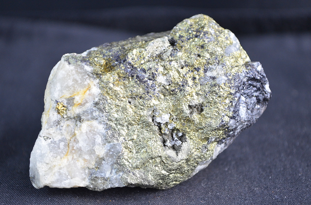
Mineralisation is patchy blebs of medium grained disseminated to matrix sulphides in the basal peridotite to olivine pyroxenite. Pyrrhotite, with sub-ordinate pentlandite, and chalcopyrite, forming lobate aggregates up to 12% volume of the Ultramafic host. Pyrrhotite forms layers up to 20 metres thick, 8 metres above the basal contact of an intrusion.
Select Mineral List Type
Standard Detailed Gallery Strunz Chemical ElementsCommodity List
This is a list of exploitable or exploited mineral commodities recorded at this locality.Mineral List
3 valid minerals.
Rock Types Recorded
Note: data is currently VERY limited. Please bear with us while we work towards adding this information!
Select Rock List Type
Alphabetical List Tree DiagramDetailed Mineral List:
| ⓘ Chalcopyrite Formula: CuFeS2 |
| ⓘ 'Fayalite-Forsterite Series' |
| ⓘ Pentlandite Formula: (NixFey)Σ9S8 |
| ⓘ Pyrrhotite Formula: Fe1-xS |
Gallery:
List of minerals arranged by Strunz 10th Edition classification
| Group 2 - Sulphides and Sulfosalts | |||
|---|---|---|---|
| ⓘ | Pentlandite | 2.BB.15 | (NixFey)Σ9S8 |
| ⓘ | Chalcopyrite | 2.CB.10a | CuFeS2 |
| ⓘ | Pyrrhotite | 2.CC.10 | Fe1-xS |
| Unclassified | |||
| ⓘ | 'Fayalite-Forsterite Series' | - | |
List of minerals for each chemical element
| O | Oxygen | |
|---|---|---|
| O | ⓘ Fayalite-Forsterite Series | |
| Mg | Magnesium | |
| Mg | ⓘ Fayalite-Forsterite Series | |
| Si | Silicon | |
| Si | ⓘ Fayalite-Forsterite Series | |
| S | Sulfur | |
| S | ⓘ Chalcopyrite | CuFeS2 |
| S | ⓘ Pentlandite | (NixFey)Σ9S8 |
| S | ⓘ Pyrrhotite | Fe1-xS |
| Fe | Iron | |
| Fe | ⓘ Chalcopyrite | CuFeS2 |
| Fe | ⓘ Pentlandite | (NixFey)Σ9S8 |
| Fe | ⓘ Pyrrhotite | Fe1-xS |
| Fe | ⓘ Fayalite-Forsterite Series | |
| Ni | Nickel | |
| Ni | ⓘ Pentlandite | (NixFey)Σ9S8 |
| Cu | Copper | |
| Cu | ⓘ Chalcopyrite | CuFeS2 |
Other Regions, Features and Areas containing this locality
Australia
- Western Australia
- Pilbara CratonCraton
- Radio Hill Nickel Metallogenic ProvinceGeologic Province
- Warakurna Large Igneous ProvinceGeologic Province
- West Australian ElementCraton
Australian PlateTectonic Plate
- West Australian Craton
- Pilbara CratonCraton
This page contains all mineral locality references listed on mindat.org. This does not claim to be a complete list. If you know of more minerals from this site, please register so you can add to our database. This locality information is for reference purposes only. You should never attempt to
visit any sites listed in mindat.org without first ensuring that you have the permission of the land and/or mineral rights holders
for access and that you are aware of all safety precautions necessary.
Radio Hill Mine, Karratha, City of Karratha, Western Australia, Australia