Bill Moose Run, Columbus, Franklin County, Ohio, USAi
| Regional Level Types | |
|---|---|
| Bill Moose Run | - not defined - |
| Columbus | - not defined - |
| Franklin County | County |
| Ohio | State |
| USA | Country |
This page is currently not sponsored. Click here to sponsor this page.
Latitude & Longitude (WGS84):
40° 4' 3'' North , 83° 1' 53'' West
Latitude & Longitude (decimal):
Köppen climate type:
Nearest Settlements:
| Place | Population | Distance |
|---|---|---|
| Riverlea | 569 (2017) | 1.7km |
| Worthington | 14,498 (2017) | 3.1km |
| Minerva Park | 1,318 (2017) | 7.5km |
| Dublin | 45,098 (2017) | 7.9km |
| Upper Arlington | 34,907 (2017) | 8.5km |
Nearest Clubs:
Local clubs are the best way to get access to collecting localities
Local clubs are the best way to get access to collecting localities
| Club | Location | Distance |
|---|---|---|
| Ohio Geological Society | Worthington, Ohio | 3km |
| Columbus Rock and Mineral Society | Columbus, Ohio | 12km |
Bill Moose Ravine is one of a series of ravines that drain into the Olentangy River in the City of Columbus. All of these ravines cut into the Ohio Shale, found in the Devonian bedrock exposed in a strip in the center of Ohio, running from Adams/Scioto counties in the south, up through the heavily populated counties along the shore of Lake Erie.
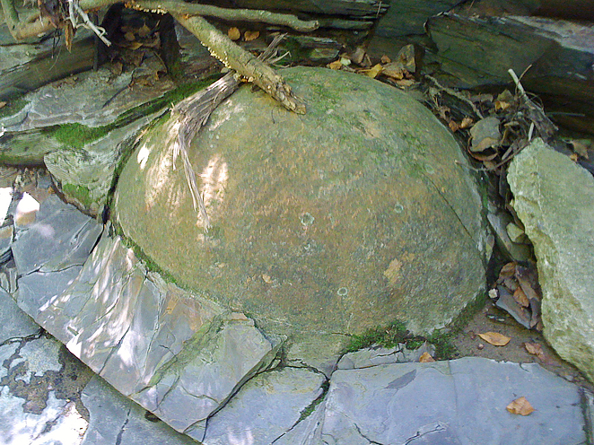
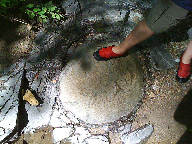
Sources describing minerals in the Ohio Shale in the northern part of the state can be applied to the Ohio Shale in general: it is a similar geology. Thus a similar pattern of mineralized concretions (containing ferroan dolomite, calcite, quartz, baryte, and aragonite), pyrite disks, and mineral efflorescences (alunogen, botryogen, copiapite, epsomite, gypsum, hexahydrite, melanterite, ferroan pickeringite, and rozenite) can be found in central Ohio exposures of the Ohio shale. In addition, chert nodules weathered out of limestone can be found in the stream beds.
Bull Run Ravine runs about 3 miles from I-71, just north of the Morse Rd. exit, west to the Olentangy River. It is easily accessible at Delawanda Park (the lat/long below), in the woods behind the game fields. Moving east, the ravine runs behind the Graceland shopping center. The Run passes under High Street, through an apartment complex, and onto the grounds of the Ohio State School for the Blind and Ohio State School for the Deaf, then pnarrows near I-71.
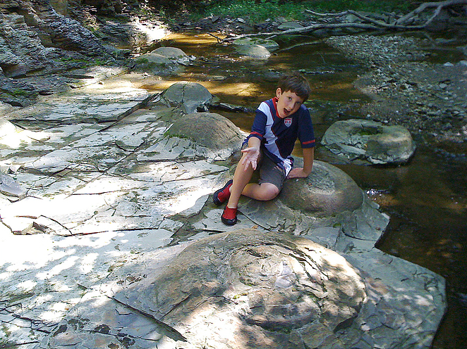
Concretions occur in the exposed shale, and chunks of concretions can be found in the stream bed. A few monster concretions can be found in the woods in Delawanda Park. Efflorescences from the breakdown of pyrite in the Ohio Shale coat some of the exposed shale. Chert nodules are also common and some interesting glacial erratics can also be found in the stream such as unakite granite containing epidote, but the source of these rocks is probably in Canada.
This is an urban site, and much of the property is private. The exception is the mouth of Bill Moose Run in Delawanda Park, which is quite woodsy and undeveloped for such an urban site.
The Run is named after Bill Moose, known as the last of the Wyandot Indians who originally lived in central Ohio. After multiple displacements of his people westward, Bill Moose returned to the Columbus area, where he lived near the area where Bill Moose Run crosses Indanola Avenue.
Select Mineral List Type
Standard Detailed Gallery Strunz Chemical ElementsMineral List
21 valid minerals.
Rock Types Recorded
Note: data is currently VERY limited. Please bear with us while we work towards adding this information!
Select Rock List Type
Alphabetical List Tree DiagramDetailed Mineral List:
| ⓘ Alunogen Formula: Al2(SO4)3 · 17H2O References: |
| ⓘ Aragonite Formula: CaCO3 References: |
| ⓘ Baryte Formula: BaSO4 References: |
| ⓘ Botryogen Formula: MgFe3+(SO4)2(OH) · 7H2O References: |
| ⓘ Calcite Formula: CaCO3 |
| ⓘ Chalcopyrite Formula: CuFeS2 Description: (Glacial erratic, not indigenous to site.) References: |
| ⓘ Copiapite Formula: Fe2+Fe3+4(SO4)6(OH)2 · 20H2O References: |
| ⓘ Dolomite Formula: CaMg(CO3)2 References: |
| ⓘ Epsomite Formula: MgSO4 · 7H2O References: |
| ⓘ Goethite Formula: Fe3+O(OH) |
| ⓘ Gypsum Formula: CaSO4 · 2H2O References: |
| ⓘ Hexahydrite Formula: MgSO4 · 6H2O References: |
| ⓘ Marcasite Formula: FeS2 |
| ⓘ Melanterite Formula: Fe2+(H2O)6SO4 · H2O References: |
| ⓘ Millerite Formula: NiS Description: (Glacial erratic, not indigenous to site.) References: |
| ⓘ Opal Formula: SiO2 · nH2O References: |
| ⓘ Pickeringite Formula: MgAl2(SO4)4 · 22H2O References: |
| ⓘ Pyrite Formula: FeS2 |
| ⓘ Quartz Formula: SiO2 References: |
| ⓘ Quartz var. Chalcedony Formula: SiO2 |
| ⓘ Rozenite Formula: FeSO4 · 4H2O References: |
| ⓘ Whewellite Formula: Ca(C2O4) · H2O |

List of minerals arranged by Strunz 10th Edition classification
| Group 2 - Sulphides and Sulfosalts | |||
|---|---|---|---|
| ⓘ | Chalcopyrite | 2.CB.10a | CuFeS2 |
| ⓘ | Millerite | 2.CC.20 | NiS |
| ⓘ | Pyrite | 2.EB.05a | FeS2 |
| ⓘ | Marcasite | 2.EB.10a | FeS2 |
| Group 4 - Oxides and Hydroxides | |||
| ⓘ | Goethite | 4.00. | Fe3+O(OH) |
| ⓘ | Quartz var. Chalcedony | 4.DA.05 | SiO2 |
| ⓘ | 4.DA.05 | SiO2 | |
| ⓘ | Opal | 4.DA.10 | SiO2 · nH2O |
| Group 5 - Nitrates and Carbonates | |||
| ⓘ | Calcite | 5.AB.05 | CaCO3 |
| ⓘ | Dolomite | 5.AB.10 | CaMg(CO3)2 |
| ⓘ | Aragonite | 5.AB.15 | CaCO3 |
| Group 7 - Sulphates, Chromates, Molybdates and Tungstates | |||
| ⓘ | Baryte | 7.AD.35 | BaSO4 |
| ⓘ | Rozenite | 7.CB.15 | FeSO4 · 4H2O |
| ⓘ | Hexahydrite | 7.CB.25 | MgSO4 · 6H2O |
| ⓘ | Melanterite | 7.CB.35 | Fe2+(H2O)6SO4 · H2O |
| ⓘ | Epsomite | 7.CB.40 | MgSO4 · 7H2O |
| ⓘ | Alunogen | 7.CB.45 | Al2(SO4)3 · 17H2O |
| ⓘ | Pickeringite | 7.CB.85 | MgAl2(SO4)4 · 22H2O |
| ⓘ | Gypsum | 7.CD.40 | CaSO4 · 2H2O |
| ⓘ | Copiapite | 7.DB.35 | Fe2+Fe3+4(SO4)6(OH)2 · 20H2O |
| ⓘ | Botryogen | 7.DC.25 | MgFe3+(SO4)2(OH) · 7H2O |
| Group 10 - Organic Compounds | |||
| ⓘ | Whewellite | 10.AB.45 | Ca(C2O4) · H2O |
List of minerals for each chemical element
| H | Hydrogen | |
|---|---|---|
| H | ⓘ Alunogen | Al2(SO4)3 · 17H2O |
| H | ⓘ Botryogen | MgFe3+(SO4)2(OH) · 7H2O |
| H | ⓘ Copiapite | Fe2+Fe43+(SO4)6(OH)2 · 20H2O |
| H | ⓘ Epsomite | MgSO4 · 7H2O |
| H | ⓘ Goethite | Fe3+O(OH) |
| H | ⓘ Gypsum | CaSO4 · 2H2O |
| H | ⓘ Hexahydrite | MgSO4 · 6H2O |
| H | ⓘ Melanterite | Fe2+(H2O)6SO4 · H2O |
| H | ⓘ Opal | SiO2 · nH2O |
| H | ⓘ Pickeringite | MgAl2(SO4)4 · 22H2O |
| H | ⓘ Rozenite | FeSO4 · 4H2O |
| H | ⓘ Whewellite | Ca(C2O4) · H2O |
| C | Carbon | |
| C | ⓘ Aragonite | CaCO3 |
| C | ⓘ Calcite | CaCO3 |
| C | ⓘ Dolomite | CaMg(CO3)2 |
| C | ⓘ Whewellite | Ca(C2O4) · H2O |
| O | Oxygen | |
| O | ⓘ Alunogen | Al2(SO4)3 · 17H2O |
| O | ⓘ Aragonite | CaCO3 |
| O | ⓘ Baryte | BaSO4 |
| O | ⓘ Botryogen | MgFe3+(SO4)2(OH) · 7H2O |
| O | ⓘ Calcite | CaCO3 |
| O | ⓘ Quartz var. Chalcedony | SiO2 |
| O | ⓘ Copiapite | Fe2+Fe43+(SO4)6(OH)2 · 20H2O |
| O | ⓘ Dolomite | CaMg(CO3)2 |
| O | ⓘ Epsomite | MgSO4 · 7H2O |
| O | ⓘ Goethite | Fe3+O(OH) |
| O | ⓘ Gypsum | CaSO4 · 2H2O |
| O | ⓘ Hexahydrite | MgSO4 · 6H2O |
| O | ⓘ Melanterite | Fe2+(H2O)6SO4 · H2O |
| O | ⓘ Opal | SiO2 · nH2O |
| O | ⓘ Pickeringite | MgAl2(SO4)4 · 22H2O |
| O | ⓘ Quartz | SiO2 |
| O | ⓘ Rozenite | FeSO4 · 4H2O |
| O | ⓘ Whewellite | Ca(C2O4) · H2O |
| Mg | Magnesium | |
| Mg | ⓘ Botryogen | MgFe3+(SO4)2(OH) · 7H2O |
| Mg | ⓘ Dolomite | CaMg(CO3)2 |
| Mg | ⓘ Epsomite | MgSO4 · 7H2O |
| Mg | ⓘ Hexahydrite | MgSO4 · 6H2O |
| Mg | ⓘ Pickeringite | MgAl2(SO4)4 · 22H2O |
| Al | Aluminium | |
| Al | ⓘ Alunogen | Al2(SO4)3 · 17H2O |
| Al | ⓘ Pickeringite | MgAl2(SO4)4 · 22H2O |
| Si | Silicon | |
| Si | ⓘ Quartz var. Chalcedony | SiO2 |
| Si | ⓘ Opal | SiO2 · nH2O |
| Si | ⓘ Quartz | SiO2 |
| S | Sulfur | |
| S | ⓘ Alunogen | Al2(SO4)3 · 17H2O |
| S | ⓘ Baryte | BaSO4 |
| S | ⓘ Botryogen | MgFe3+(SO4)2(OH) · 7H2O |
| S | ⓘ Chalcopyrite | CuFeS2 |
| S | ⓘ Copiapite | Fe2+Fe43+(SO4)6(OH)2 · 20H2O |
| S | ⓘ Epsomite | MgSO4 · 7H2O |
| S | ⓘ Gypsum | CaSO4 · 2H2O |
| S | ⓘ Hexahydrite | MgSO4 · 6H2O |
| S | ⓘ Marcasite | FeS2 |
| S | ⓘ Melanterite | Fe2+(H2O)6SO4 · H2O |
| S | ⓘ Millerite | NiS |
| S | ⓘ Pickeringite | MgAl2(SO4)4 · 22H2O |
| S | ⓘ Pyrite | FeS2 |
| S | ⓘ Rozenite | FeSO4 · 4H2O |
| Ca | Calcium | |
| Ca | ⓘ Aragonite | CaCO3 |
| Ca | ⓘ Calcite | CaCO3 |
| Ca | ⓘ Dolomite | CaMg(CO3)2 |
| Ca | ⓘ Gypsum | CaSO4 · 2H2O |
| Ca | ⓘ Whewellite | Ca(C2O4) · H2O |
| Fe | Iron | |
| Fe | ⓘ Botryogen | MgFe3+(SO4)2(OH) · 7H2O |
| Fe | ⓘ Chalcopyrite | CuFeS2 |
| Fe | ⓘ Copiapite | Fe2+Fe43+(SO4)6(OH)2 · 20H2O |
| Fe | ⓘ Goethite | Fe3+O(OH) |
| Fe | ⓘ Marcasite | FeS2 |
| Fe | ⓘ Melanterite | Fe2+(H2O)6SO4 · H2O |
| Fe | ⓘ Pyrite | FeS2 |
| Fe | ⓘ Rozenite | FeSO4 · 4H2O |
| Ni | Nickel | |
| Ni | ⓘ Millerite | NiS |
| Cu | Copper | |
| Cu | ⓘ Chalcopyrite | CuFeS2 |
| Ba | Barium | |
| Ba | ⓘ Baryte | BaSO4 |
Other Regions, Features and Areas containing this locality
North AmericaContinent
North America PlateTectonic Plate
- Granite-Rhyolite ProvinceMagmatic Province
- Shawnee DomainDomain
This page contains all mineral locality references listed on mindat.org. This does not claim to be a complete list. If you know of more minerals from this site, please register so you can add to our database. This locality information is for reference purposes only. You should never attempt to
visit any sites listed in mindat.org without first ensuring that you have the permission of the land and/or mineral rights holders
for access and that you are aware of all safety precautions necessary.
Bill Moose Run, Columbus, Franklin County, Ohio, USA