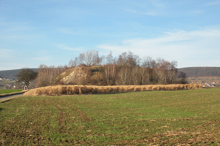
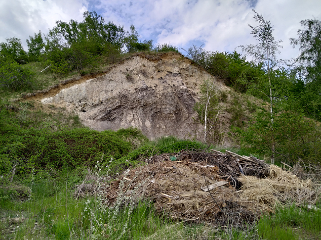
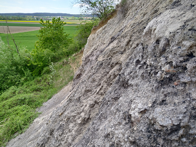
Lignite mine, Hausheim, Wölbling, Sankt Pölten-Land District, Lower Austria, Austriai
| Regional Level Types | |
|---|---|
| Lignite mine | Mine |
| Hausheim | - not defined - |
| Wölbling | Municipality |
| Sankt Pölten-Land District | District |
| Lower Austria | State |
| Austria | Country |
This page is currently not sponsored. Click here to sponsor this page.
Latitude & Longitude (WGS84):
48° 18' 29'' North , 15° 36' 2'' East
Latitude & Longitude (decimal):
Type:
Köppen climate type:
Nearest Settlements:
| Place | Population | Distance |
|---|---|---|
| Hausheim | 183 (2018) | 0.6km |
| Anzenhof | 177 (2018) | 0.8km |
| Oberwölbling | 1,151 (2018) | 1.2km |
| Absdorf | 490 (2018) | 1.4km |
| Ambach | 291 (2018) | 1.4km |
Name(s) in local language(s):
Braunkohlelagerstätte, Hausheim (Statzendorf), Wölbling, Dunkelsteinerwald, Mostviertel, Niederösterreich, Österreich
Former lignite mining.
Minerals listed were found on an old mining dump N of Hausheim.
Located south of Oberwölbling and west of Statzendorf.
Select Mineral List Type
Standard Detailed Gallery Strunz Chemical ElementsMineral List
4 valid minerals.
Rock Types Recorded
Note: data is currently VERY limited. Please bear with us while we work towards adding this information!
Select Rock List Type
Alphabetical List Tree DiagramDetailed Mineral List:
| ⓘ Alunogen Formula: Al2(SO4)3 · 17H2O References: |
| ⓘ Gypsum Formula: CaSO4 · 2H2O |
| ⓘ Halotrichite Formula: FeAl2(SO4)4 · 22H2O |
| ⓘ Native Sulphur Formula: S8 References: |
Gallery:

List of minerals arranged by Strunz 10th Edition classification
| Group 1 - Elements | |||
|---|---|---|---|
| ⓘ | Native Sulphur | 1.CC.05 | S8 |
| Group 7 - Sulphates, Chromates, Molybdates and Tungstates | |||
| ⓘ | Alunogen | 7.CB.45 | Al2(SO4)3 · 17H2O |
| ⓘ | Halotrichite | 7.CB.85 | FeAl2(SO4)4 · 22H2O |
| ⓘ | Gypsum | 7.CD.40 | CaSO4 · 2H2O |
List of minerals for each chemical element
| H | Hydrogen | |
|---|---|---|
| H | ⓘ Alunogen | Al2(SO4)3 · 17H2O |
| H | ⓘ Gypsum | CaSO4 · 2H2O |
| H | ⓘ Halotrichite | FeAl2(SO4)4 · 22H2O |
| O | Oxygen | |
| O | ⓘ Alunogen | Al2(SO4)3 · 17H2O |
| O | ⓘ Gypsum | CaSO4 · 2H2O |
| O | ⓘ Halotrichite | FeAl2(SO4)4 · 22H2O |
| Al | Aluminium | |
| Al | ⓘ Alunogen | Al2(SO4)3 · 17H2O |
| Al | ⓘ Halotrichite | FeAl2(SO4)4 · 22H2O |
| S | Sulfur | |
| S | ⓘ Alunogen | Al2(SO4)3 · 17H2O |
| S | ⓘ Gypsum | CaSO4 · 2H2O |
| S | ⓘ Halotrichite | FeAl2(SO4)4 · 22H2O |
| S | ⓘ Native Sulphur | S8 |
| Ca | Calcium | |
| Ca | ⓘ Gypsum | CaSO4 · 2H2O |
| Fe | Iron | |
| Fe | ⓘ Halotrichite | FeAl2(SO4)4 · 22H2O |
Other Regions, Features and Areas containing this locality
Austria
- Lower Austria
- DunkelsteinerwaldForest
- ⭔MostviertelQuarter
Eurasian PlateTectonic Plate
- Rheno-Hercynian BeltOrogenic Belt
EuropeContinent
This page contains all mineral locality references listed on mindat.org. This does not claim to be a complete list. If you know of more minerals from this site, please register so you can add to our database. This locality information is for reference purposes only. You should never attempt to
visit any sites listed in mindat.org without first ensuring that you have the permission of the land and/or mineral rights holders
for access and that you are aware of all safety precautions necessary.
Lignite mine, Hausheim, Wölbling, Sankt Pölten-Land District, Lower Austria, Austria