| Locality type: | Occurrence |
| Classification |
|---|
|
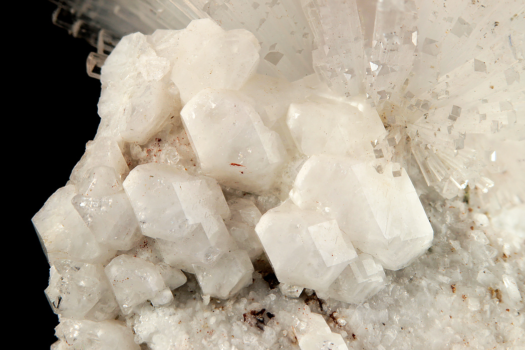
| Species: | 'Apophyllite Group' (not an IMA approved species) |
| Formula: | AB4[Si8O20]X · 8H2O |
| Comments: | crystals to 5mm associated with natrolite |
| Habit: | bipyramidal modified by prism |
| Colour: | white |
| Confirmation |
|---|
|
| Validity: | Confirmed |
| Confirmation Methods: | Visually Identified |
| Associated Minerals Based on Photo Data: |
|---|
|
| Natrolite | 6 |
| Data |
|---|
|
| Mineral Data: | Click here to view Apophyllite Group data |
| Locality Data: | Click here to view State Route 57 zeolite occurrence (Georgetown locality; Connerie's store), Redding, Fairfield County, Connecticut, USA |
| Data Identifiers |
|---|
|
| Mindat Occurrence Record ID: | 837950 |
| Long-form Identifier: | 1:3:837950:4 |
| GUID (UUID V4): | 0 |
| Nearest other occurrences of Apophyllite Group |
|---|
|
|
| 19.1km (11.8 miles) | ⓘInterstate 95 exit 24, Fairfield, Fairfield County, Connecticut, USA |
| 19.8km (12.3 miles) | ⓘSky Ridge railroad cut, Hawleyville, Newtown, Fairfield County, Connecticut, USA |
| 21.3km (13.2 miles) | ⓘInterstate 84 road cuts (Route 6A bypass), Newtown, Fairfield County, Connecticut, USA |
| 25.0km (15.5 miles) | ⓘTilly Foster Iron Mine, Town of Southeast, Putnam County, New York, USA |
| 32.0km (19.9 miles) | ⓘSawteeth Ridge, Southbury, New Haven County, Connecticut, USA |
| 33.7km (20.9 miles) | ⓘO & G Southbury Quarry (Silliman Quarry; O & G No. 2 Quarry), Orenaug Hills, Woodbury, Litchfield County, Connecticut, USA |
| 37.2km (23.1 miles) | ⓘO & G Woodbury Traprock Quarry (Orenaug Quarry; O & G No. 1 Quarry), Orenaug Hills, Woodbury, Litchfield County, Connecticut, USA |
| 43.4km (27.0 miles) | ⓘRockland Lake Landing, Rockland Lake, Clarkstown, Rockland County, New York, USA |
| 51.0km (31.7 miles) | ⓘCheshire Traprock Quarry, Cheshire, New Haven County, Connecticut, USA |
| 57.5km (35.7 miles) | ⓘThomaston Dam railroad cut, Thomaston Dam, Thomaston, Litchfield County, Connecticut, USA |
| References |
|---|
|
|

State Route 57 zeolite occurrence, Redding, Fairfield County, Connecticut, USA