
|
|
Related Sections - Applications Gallery - States - School Districts - Metros - Congressional District - Counties - Tracts/Neighborhoods - Block Groups - Census Blocks - ZIP Codes - Urban Areas Estimates-Projections - 2060 Demographic ... all county interactive table - 2030 Demographic-Economic - Single Year of Age GIS Thematic Mapping Visual Analysis Tools Ranking Tables National Scope Demographic Change 2000-2010 - States - Metros - Congressional District - School Districts - Counties - Cities/Places - Census Tracts |
Census 2010 Demographics for Census 2000 Geography
Examining Diversity 1960-2060 Support & Technical Assistance help using these resources |
|
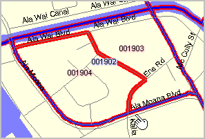
Honolulu Census Tracts 2000-2010 Illustration of Census Tract Change |
|
| St00 | 2000 State FIPS Code |
| GeoID00 | 2000 State FIPS code + county FIPS code + Census 2000 tract code |
| Pop00 | 2010 Population of the 2000 Tract |
| HU00 | 2010 Housing Unit Count of the 2000 Tract |
| Pt00 | 2000 Tract Part Flag |
| St10 | 2010 State FIPS Code |
| GeoID10 | 2010 State FIPS code + county FIPS code + Census 2010 tract code |
| Pop10 | 2010 Population of the 2010 Tract |
| HU10 | 2010 Housing Unit Count of the 2010 Tract |
| Pt10 | 2010 Tract Part Flag |
| Pop10pt | Calculated 2010 Population for the relationship record |
| HU10pt | Calculated 2010 Housing Unit count for the relationship record |
|
|